- Getting Started
- Hardware
- Bricks
- Bricklets
- Accelerometer Bricklet 2.0
- Air Quality Bricklet
- Ambient Light Bricklet 3.0
- Analog In Bricklet 3.0
- Analog Out Bricklet 3.0
- Barometer Bricklet
- Barometer Bricklet 2.0
- Breakout Bricklet
- CAN Bricklet
- CAN Bricklet 2.0
- CO2 Bricklet 2.0
- Color Bricklet
- Color Bricklet 2.0
- Compass Bricklet
- DC Bricklet 2.0
- Distance IR Bricklet
- Distance IR Bricklet 2.0
- Distance US Bricklet 2.0
- DMX Bricklet
- Dual Button Bricklet 2.0
- Dust Detector Bricklet
- E-Paper 296x128 Bricklet
- Energy Monitor Bricklet
- GPS Bricklet 2.0
- GPS Bricklet 3.0
- Hall Effect Bricklet
- Hall Effect Bricklet 2.0
- Humidity Bricklet 2.0
- IMU Bricklet 3.0
- Industrial Analog Out Bricklet 2.0
- Industrial Counter Bricklet
- Industrial Digital In 4 Bricklet 2.0
- Industrial Digital Out 4 Bricklet
- Industrial Digital Out 4 Bricklet 2.0
- Industrial Dual 0-20mA Bricklet
- Industrial Dual 0-20mA Bricklet 2.0
- Industrial Dual AC In Bricklet
- Industrial Dual AC Relay Bricklet
- Industrial Dual Analog In Bricklet 2.0
- Industrial Dual Relay Bricklet
- Industrial PTC Bricklet
- Industrial Quad Relay Bricklet 2.0
- IO-16 Bricklet
- IO-16 Bricklet 2.0
- IO-4 Bricklet 2.0
- Isolator Bricklet
- Joystick Bricklet
- Joystick Bricklet 2.0
- Laser Range Finder Bricklet 2.0
- LCD 128x64 Bricklet
- LCD 20x4 Bricklet
- LED Strip Bricklet 2.0
- Line Bricklet
- Linear Poti Bricklet
- Linear Poti Bricklet 2.0
- Load Cell Bricklet 2.0
- Motion Detector Bricklet 2.0
- Motorized Linear Poti Bricklet
- Multi Touch Bricklet
- Multi Touch Bricklet 2.0
- NFC Bricklet
- OLED 128x64 Bricklet 2.0
- OLED 64x48 Bricklet
- One Wire Bricklet
- Outdoor Weather Bricklet
- Particulate Matter Bricklet
- Performance DC Bricklet
- Piezo Speaker Bricklet
- Piezo Speaker Bricklet 2.0
- Real-Time Clock Bricklet
- Real-Time Clock Bricklet 2.0
- Remote Switch Bricklet 2.0
- RGB LED Bricklet 2.0
- RGB LED Button Bricklet
- Rotary Encoder Bricklet 2.0
- Rotary Poti Bricklet
- Rotary Poti Bricklet 2.0
- RS232 Bricklet
- RS232 Bricklet 2.0
- RS485 Bricklet
- Segment Display 4x7 Bricklet
- Segment Display 4x7 Bricklet 2.0
- Servo Bricklet 2.0
- Silent Stepper Bricklet 2.0
- Solid State Relay Bricklet 2.0
- Sound Intensity Bricklet
- Sound Pressure Level Bricklet
- Temperature Bricklet
- Temperature Bricklet 2.0
- Temperature IR Bricklet 2.0
- Thermal Imaging Bricklet
- Thermocouple Bricklet 2.0
- Tilt Bricklet
- UV Light Bricklet 2.0
- Voltage/Current Bricklet 2.0
- XMC1400 Breakout Bricklet
- Master Extensions
- Power Supplies
- Discontinued Products
- Timeline
- Software
- Kits
- Embedded Boards
- Specifications
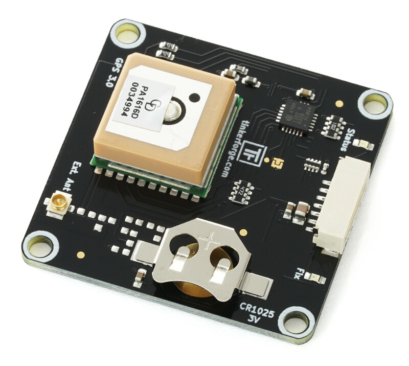
GPS Bricklet 3.0


Features
Supports GPS, GLONASS and Galileo simultaneously
Receives movement-, position-, altitude, time data and PPS signal
Elevation, azimuth and SNR for each GPS/GLONASS/Galileo satellite accessible
99 channels, 10Hz update rate
High sensitivity and accuracy, interference canceller
Description
The GPS Bricklet 3.0 can be used to extend Bricks by the possibility to determine their position via GPS. Additionally it is possible to receive movement (direction and velocity), altitude (altitude and geodial separation), as well as high precise time/date information and PPS signal.
Current values for elevation, azimuth and SNR for each of the GPS, GLONASS and Galileo satellites can be read out.
The GPS module is optimized to get a fast fix, has a high input sensitivity (-165dBm) and a update rate of 10Hz suitable for drones or the like. Internal interference canceller rejects RF interference from other devices like Bluetooth or Wi-Fi.
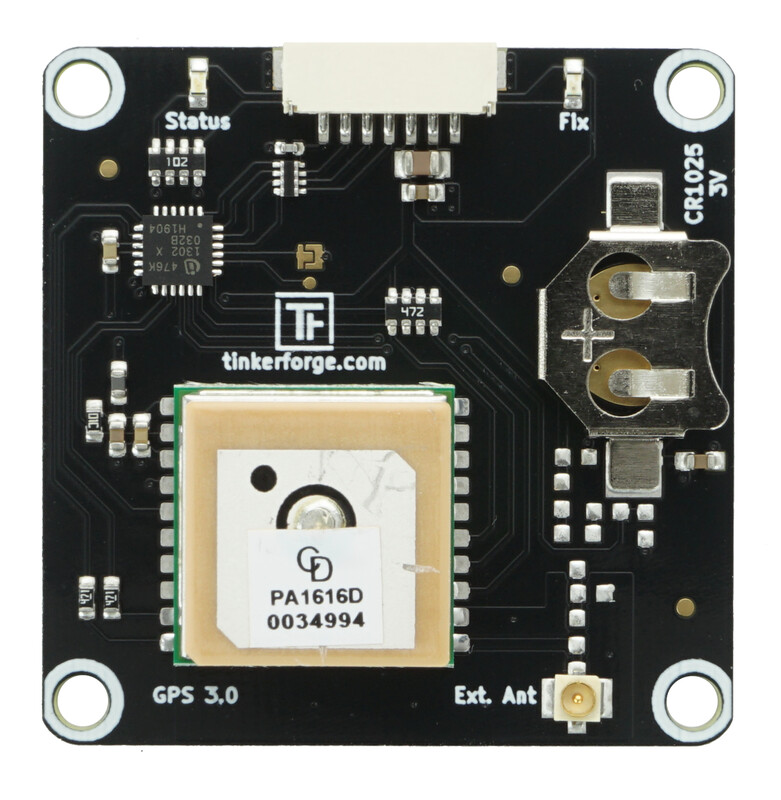
The Bricklet hast an internal antenna. Through a U.FL connector you can also connect an external antenna.
A CR1025 coin cell battery is also included. It is used as a battery backup for the last satellite position data. With this information a fix can be obtained faster if the power was lost.
Technical Specifications
Property |
Value |
|---|---|
GPS Module Chipset |
CDTop PA1616D |
Sensitivity |
-148dBm (acquisition), -165dBm (tracking)* |
Position Accuracy |
3.0m (50% CEP)* |
Time to first Fix |
< 35s (without battery), < 1s (with battery)* |
Update Rate |
10Hz |
Dimensions (W x D x H) |
40 x 40 x 12mm (1.57 x 1.57 x 0.47") |
Weight |
20g (with battery) |
Current Consumption |
approx. 73mA |
* datasheet values
Resources
External Antenna
The GPS Bricklet 3.0 has an internal antenna that is used by default. You can connect an external antenna to the U.FL connector. If an external antenna is connected the Bricklet will auomatically switch to the external antenna und the internal antenna is not used anymore. A compatible antenna with a long lead is available in the shop.
The antenna should always look upwards, so if you use the antenna that is attached to the bottom you need to mount the Bricklet accordingly.
Test your GPS Bricklet 3.0
To test a GPS Bricklet 3.0 you need to have Brick Daemon and Brick Viewer installed. Brick Daemon acts as a proxy between the USB interface of the Bricks and the API bindings. Brick Viewer connects to Brick Daemon. It helps to figure out basic information about the connected Bricks and Bricklets and allows to test them.
Connect the GPS Bricklet 3.0 to a Brick with a Bricklet Cable.
If you connect the Brick to the PC over USB, you should see a new tab named "GPS Bricklet 3.0" in the Brick Viewer after a moment. Select this tab. If everything went as expected the Brick Viewer should look as depicted below.
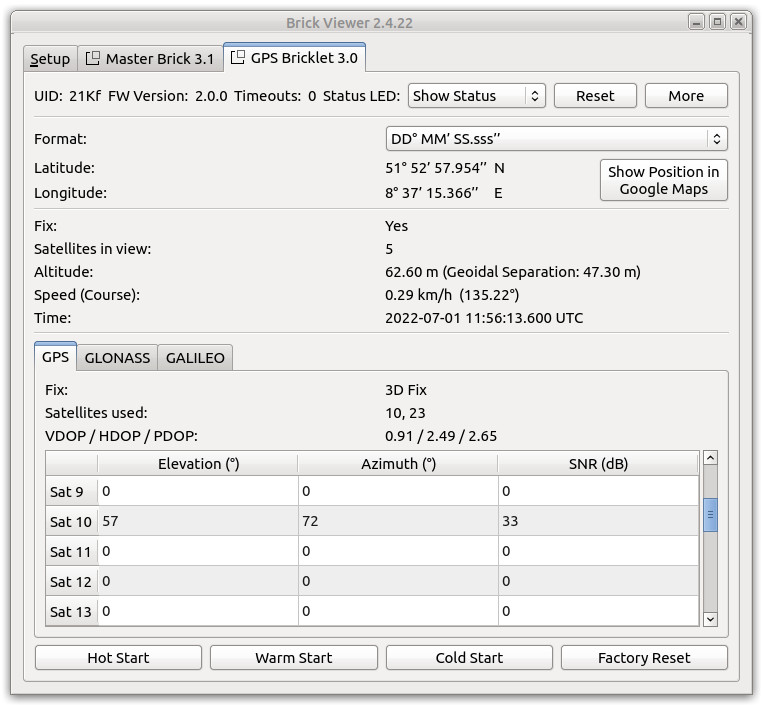
After this test you can go on with writing your own application. See the Programming Interface section for the API of the GPS Bricklet 3.0 and examples in different programming languages.
Fix LED
The green LED labeled "Fix" indicates the status of the position data. The LED blinks during fix acquisition and is turned on if a fix is achieved.
If the GPS module is battery powered the LED is turned off to save power.
Case
TBD
Programming Interface
See Programming Interface for a detailed description.
Language |
API |
Examples |
Installation |
|---|---|---|---|
C/C++ |
|||
C/C++ for Microcontrollers |
|||
C# |
|||
Delphi/Lazarus |
|||
Go |
|||
Java |
|||
JavaScript |
|||
LabVIEW |
|||
Mathematica |
|||
MATLAB/Octave |
|||
MQTT |
|||
openHAB |
|||
Perl |
|||
PHP |
|||
Python |
|||
Ruby |
|||
Rust |
|||
Shell |
|||
Visual Basic .NET |
|||
TCP/IP |
|||
Modbus |